

Bent Creek Loop
Posted By auntie on December 22, 2020
9.15 miles; 1,261-feet total ascent; Asheville
That’s kind of a generic name, but there are so many trails in this area. This hike included parts of the Boyd Branch Trail, the Boyd Logging Trail, the Little Hickory Top Trail, North Boundary Road, the Greens Lick Trail, Laurel Branch Road, and the Lower Sidehill Trails. It was tough going, and longer than it needed to be because I missed a turn and had to backtrack. Great views from the high point, tho.

Worst Water Crossing
I was a bit concerned when I mapped this hike out because of all the water crossings, but the one above turned out to be the worst one, and I didn’t even get my boots wet. And the sections that were on forest roads were built so that streams ran through buried culverts. Easy peasy!

Observation Wellhead
This was interesting. I came to a spot where the single-track trail I was on intersected one of those forest roads. It was a large clearing with picnic tables and this USGS observation wellhead.

Forest Road
These aren’t really roads, in the sense that you’d want to drive your car down them, but they’re still straight, level, and kind of boring to walk on. Fortunately this hike was a very nice mix of single track woodland trails and forest roads, so it was hard to get too bored with any one section.

View
This hike just barely kisses the track I was on in November that I called the Wolf Knob Loop. I picked up the North Boundary Road pretty much where I left off then, and it continued to climb, though not severely. This was by far the best view on the whole trail. Again, I’m guessing those distant mountains are the Great Smokies.
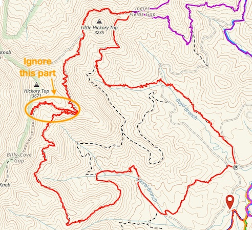
As I mentioned above, I kind of got off track on this hike and started heading out towards Billy Cove Gap. In my defense, the turn I missed was almost parallel to the trail I was on, just below it, so at first glance at the GPS, it looked right. It wasn’t until I took another glance, about 1/4 mile further, that I realized I had missed the turn. When I got back to the intersection there were some helpful mountain bikers who pointed me in the right direction, and warned me to keep alert for other mountain bikers, as this stretch is a popular downhill run.
Anyway, you can find out more about this trail network from this excellent mountain biking site, which includes links to specific trails and maps. As always, click the image above for details about this hike and to download the gps track.

Comments
Leave a Reply