The Walking Posts

The posts labeled with the little “Truckin’ ” man are from my Walking Journal, which I've been keeping since January 1, 2012. What began as a simple New Year's Resolution to exercise more quickly morphed into a hiking addiction. Below are some running totals.

  MILES TIME ASCENT CALORIES
October 2022 18.06 7h 44m 1399 1463
Year to Date 434.83 194h 24m 32,563 31,433
October Avg. 49.61 24h 19m 508 3,998

Hemp Hill Knob

Posted By on June 23, 2020

5.64 miles; Waynesville, NC

Ever since having gorged on Appalachian Trail books, I’ve been fascinated by the idea of “balds,” which are mountain tops devoid of big trees which give fantastic views of the surrounding mountains. Well, I live in Western North Carolina, and there are more than a few of them in the area. Thought I’d visit this one, finally.

Wildflowers!

Wildflowers!

Any visit to the mountains around here in spring is sure to overwhelm with wildflowers. So many wildflowers!

Great Spangled Fritillary (Speyeria cybele)

And of course, where you have wildflowers, you have butterflies. Love this so much!

The Trail

This was, for the most part, not a difficult or strenuous hike by any stretch of the imagination. It was mostly a gravel road that went to the bald, the location of the Appalachian Highland Science Learning Center, where they host tours and educational groups, so there was even some automobile traffic.

The Views!

The views, even from the trail, were stunning.

Atop the Bald

And once you get to the actual bald… breathtaking. This is not, however, your typical mountain bald. This is a lawn. Still, pretty astonishing.

Signage

Once past the Science Center, the trail does finally go into the woods for a stretch before coming back to the gravel road.

Ferguson Cabin

There was a small side trail on the way back that pointed to the “Ferguson Cabin.” And what might that be, you ask? I’ll tell ya. The Ferguson Cabin was built in 1874, by John Love Ferguson. Ferguson Cabin is the highest cabin in the Great Smoky Mountains National Park, at 4700 feet. The Ferguson family lived and farmed here until 1902.

You can find out more about the Appalachian Highland Science Learning Center at this link. As always, click the image above for details about this hike and to download the gps track.

Richmond Hill Trails

Posted By on May 21, 2020

Richmond Hill Trails

4.2 miles; Asheville, NC

I’ve been passing signs for this park for a while and finally decided to go check it out. Nice woodland trails, but after all the recent rain it was a bit muddy.

Unnamed Creek

This is a pretty trail system, if not too well marked. They don’t blaze any of the trails, they just put up a sign at trail intersections. The purple trail follows an unnamed creek which feeds into Smith Creek, both of which were running pretty well.

Railroad Track

The northernmost part of the Orange trail had a little extension that ended at the railroad tracks, and you could see the French Broad River beyond them.

Smith Creek

As I mentioned, these trails aren’t blazed, per se, and there are many many side trails and intersecting trails and crossover trails. There is a map I found online, but the colors of the trails on that map have little to no correlation to the actual colors on the ground, and there are way more colors on site, too. I had originally downloaded a track from AllTrails, and I got turned around even trying to follow it. As you will see on my map of my journey, below… there’s a part you just gotta ignore.

Another Track and River View

It’s easier to see the French Broad River on the far side of the railroad tracks in this shot. This was on the Brown trail? I think? I lost track, so to speak.

Mapleleaf Viburnum

There were some wildflowers to be seen, too, but not a huge variety. Lot of Lyreleaf Sage. Tons of that. Some viburnum, and a lot of fleabane.

You can find the map of dubious value as well as some more info on Richmond Hill Park at this “Friends of” website. Oh, I forgot to mention that there is a large disc golf course at the park also. And as always, click the image above for details about this hike and to download the gps track.

Walker Creek Trail

Posted By on May 13, 2020

Walker Creek Trail

7.02 miles; Barnardsville, NC

Hey, Beakers, sorry for the long wait between posts. Been feeling a bit down, so I haven’t been out as much as I should. That said, this last one almost killed me!

I felt I needed a short-ish hike to get back into the swing of things, and picked this one in the Pisgah National Forest. AllTrails had the track, which measured 4.09 miles long, and although I could see it was a fairly strenuous hike (over 1200-ft elevation gain), I figured I could do anything for 4 miles.

You can see this one coming, right? If not, just look at the top of the post. This WAS NOT a 4-mile hike, and when I say it was hard… it was a lollipop loop, and 3/4 of the loop was uphill. The other quarter of the loop was very, very steeply downhill. My legs were shaking like jelly in an earthquake by the time I made it back to my car.

Weak Bridge

Parking was in front of this little camp/retreat called Mountain Light Sanctuary. And yeah, no, not crossing that bridge.

Log “Bridge”

On the other hand, the Weak Bridge looks like the GW in Manhattan compared to this actual “bridge” on the trail. That is a very vigorous water flow, and probably knee-deep on me in spots. And this was on the “stem” part of the lollipop, so I knew I’d have to cross it again to get back to my car. [Ed. I did, and didn’t get wet through some miracle of physics.] Eesh. North Carolina and bridges… what’s the danged deal here???

Gorgeous

All my whining aside, this was a gorgeous hike. The woods were lush and so sweetly-scented, and there were no bugs to speak of. And this hike is bounded by two mountain creeks—you can hear the flow of water for most of the way.

Wildflowers!!!!

In fact, if it weren’t for how strenuous this hike was I’d have been in heaven. I took photos of 22 individual wildflowers on this hike. I even recognized a lot of them, but certainly not all. It was so amazing. [Ed. Note: for a more detailed investigation of the various species see my Facebook page, where I highlight one wildflower a day.] I used to hike with the Rhode Island Wild Plant Society’s Lisa Gould, who was originally from North Carolina, and used to extol the abundance to be seen here. I get it now. And interestingly, the fact that there were so many plants I recognized is not a coincidence, as the glaciers which covered most of the northeastern US at one time ended in what is now North Carolina, and dragged lots of seeds and plants south with them at their furthest reach. There is a lot of overlap between the flora of RI and NC, is what I’m saying…

Deadfall

There was a lot of deadfall on the downhill stretch of this trail. It must have once been a hemlock forest, and I saw some amazing Reishi mushrooms on the massive old hemlock logs that sprawled across the trail.

Indian Cave?

As you can see there’s a rock wall in front of this giant glacial erratic. Do you suppose it is Native American in origin? Curious.

You can find out more about the Pisgah National Forest from this website. As always, click the image above for details about this hike and to download the gps track. Just be warned… it’s 7.02 miles!!!

Westerly Grills All the Things

Posted By on April 19, 2020

Westerly Grills All the Things

5.5 miles; Westerly, RI

[This is a post from the distant past. I’ve been poking through the vast number of Draft posts on my site to see if there’s anything that might still be of interest. Thought I’d throw this one into the mix.]

Way back in the Before Times, I had planned to lead a hike on the wonderful Westerly Land Trust property called “The Grills.” In preparation for that I wanted to scout out a route that hit ALL the highlights but without too much backtracking. I think I succeeded. This would be a good hike, if the weather and the virus ever cooperate!

River view

From the parking lot, the route follows the combined blue/orange trail, and when the blue trail takes a hard right, so does this hike, where the trail quickly slopes down to the banks of the Pawcatuck River. For me, this stretch is the highlight of the whole hike, with water views to either side.

High Water Cairn

High Water Cairn

After crossing Kedinker Island on the blue trail, your next highlight is the High Water Cairn. This marks the highest point of the 2010 floods. It’s an astonishing 8 feet or so tall. And off on the right-hand side of the photo is the next highlight…

shiny new polly coon bridge

Polly Coon Bridge

…the magnificent Polly Coon Bridge. This was a joint project by the Westerly and Hopkinton Land Trusts, and connects the two Grills properties. Not far from here the blue trail intersects with the yellow trail. Oh, and there is a canoe landing on the blue trail, and two canoe landings on the yellow.

Former Camp Site

The above photo is on the yellow, or River Loop trail, at the first of the two canoe landings. When I first started coming here this was the site of a major camping/party spot, with a massive rock fire pit and lots of junk, like plastic chairs and metal grates and discarded trash. Westerly Land Trust volunteers cleaned the spot up brilliantly a few years ago, and converted the big rock fire pit into a cairn.

Larkin Farm Foundation

Also in the last year or so, several new trails were opened up on the property, including the newly-blazed white trail that goes by the site of a very old farmhouse foundation. I joined the white trail from the yellow.

View from atop Big Hill

View from atop Big Hill

Eventually, the white trail intersects the red trail, and I followed that to the next highlight, the imaginatively-named Big Hill, which gives a view out over Newton Swamp. At this point I went off the blazed trails, and followed an old farming road down off the Big Hill and north to intersect the blue trail again.

A Revolutionary War Soldier

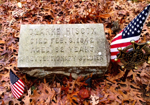
“A Revolutionary War Soldier”

A bit further down the blue trail there’s a short side trail that takes you to an old OLD cemetery. It’s in a lovely spot that overlooks a bend in the river.

big rock on the x-country trail

“Big Rock” on the old Westerly HS Cross-country Trail

From the cemetery I followed the blue trail back out to the old road, where I shortly picked up the orange trail, which is also the former Westerly High Cross-Country trail (the team has since moved to Woody Hill Management Area for their runs), where we find the similarly imaginatively-named Big Rock. To be fair, it’s a really pretty big rock…

Handicapped Access Deer Blind

The only bit of backtracking I had to do on this whole hike was to see the Handicapped Access Deer Blind (the Grills is an active hunting preserve, remember), just off the orange trail. It’s quite luxurious.

From here I backtracked to the part of the orange trail that follows the old road, and then to the teal trail, a.k.a. the Douglas Park trail. This is a weirdly paved “trail,” and somewhat mysterious, or at least it was the first time I hiked it.
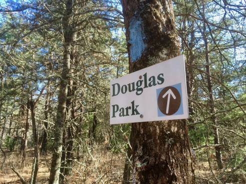
Another Mystery

Another Mystery

However I wrote to the Westerly Land Trust to ask about it, since I couldn’t find anything on line, and here was their reply:

Back in the early 1900’s when BDA (Bradford Dye Association) was in their glory days, many of the mill workers lived on Bowling Lane (the street leading up to Grills Preserve). Because of this, BDA decided to build Douglas Park to give their workers something to do. This was a park for baseball and soccer and could hold up to 300 fans! The park was built in 1920. After numerous years of use the park became abandoned. In its place trees began to grow and now a pine forest stands. This area is now a permanent part of Grills Preserve. The road that you see was the road that people used to get to the park for games.
So, mystery solved. There isn’t anything much to see besides the pavement on the trail… nothing now remains of Douglas Park.
The teal trail connects back up to the orange trail, which takes you back to the parking area. And that is my Westerly Grills, All The Things hike.

You can find out more about The Grills and download an excellent trail map from the Westerly Land Trust website. As always, click the image above for details about this hike and to download the gps track.

Hominy Creek Greenway

Posted By on April 6, 2020

.85 miles; Asheville, NC

Pretty little trail that follows Hominy Creek. It was only .85-mile long, but the walk to and from was “a bit” longer than that. I totaled 7-1/2 miles on this stroll.

Shop • Drink • Get Married

Walking through West Asheville is always fun. There are some pretty interesting shops and restaurants, including this one, one of my favorites. Fleetwood’s Rock’n’roll Wedding Chapel and Bar, AND Vintage Shop. Too bad about them not being open.

Trail Head Kiosk

This little greenway was very close to I-26, and the parking lot was actually surprisingly full considering I barely met anyone as I walked along the trail.

The Trail

This trail is not paved, which is kind of a nice change of pace. Springtime is really moving along down here. I believe that burst of yellow is Golden Ragwort.

Hominy Creek

There’s even a nice little beach along this trail, with a sandy gravelly surface. Dogs really love this spot according to the reviews on AllTrails.

Philadelphia Fleabane

I have no idea whether or not this plant originated in Philadelphia, nor do I know if it’s particularly fatal to fleas, but it is bright and sunny and happy-looking. I’m documenting the various wildflowers I see on my jaunts, which should be of special interest to my Northern friends. Be sure to “Like” the Auntie Beak’s Place Facebook page, or follow me on Twitter, so you don’t miss any.

You can find out more about the Hominy Creek Greenway and indeed all the City of Asheville Greenways, from this city website. As always, click the image above for details about this hike and to download the gps track.

Two Asheville Greenways

Posted By on March 30, 2020

2.1 miles; Asheville, NC

Today was a lovely long walk to two very nice greenway trails in Asheville: Reed Creek Greenway and Glenn’s Creek Greenway. They basically meet at the North Carolina Botanical Gardens, which were, of course, closed. Also, a bonus stroll through a technically closed Weaver Park.

Several Days Ago

As I’ve mentioned before, I walk to these walks, and here’s a sight I saw on my way to another walk a few days ago. Ah, Asheville! But wait…

Today

Somebody’s been busy! And we’re on lockdown.

Reed Creek Greenway entrance

Anyway, these two greenways, Reed Creek and Glenn’s Creek. I started at the beginning of the Reed Creek Greenway. It’s a paved walk, nice and wide—plenty of room for social distancing. Except for a lady in front of me, who had a woodchuck basically try to tackle her. Very weird. It kind of ran over her feet and into the tall grass on the other side of the fence, where it stopped and posed for photos. I missed it, but she got some great shots…

Chalk Art

Asheville is a pretty artsy place, and there was lots of chalk art on both of these paved greenways. Thought this one was especially nice! I’ll try and remember to take more photos.

California Buttercup

Saw this little beauty on the Glenn’s Creek Greenway, which is actually on the edge of the UNC Asheville campus. I’m documenting the various wildflowers I see on my jaunts, which should be of special interest to my Northern friends. Be sure to “Like” the Auntie Beak’s Place Facebook page, or follow me on Twitter, so you don’t miss any.

You can find out more about the Reed Creek Greenway and the Glenn’s Creek Greenway, and indeed all the City of Asheville Greenways, from this city website. A brief blurb about Weaver Park info can be found here. As always, click the image above for details about this hike and to download the gps track.