The Walking Posts

The posts labeled with the little “Truckin’ ” man are from my Walking Journal, which I've been keeping since January 1, 2012. What began as a simple New Year's Resolution to exercise more quickly morphed into a hiking addiction. Below are some running totals.

  MILES TIME ASCENT CALORIES
October 2022 18.06 7h 44m 1399 1463
Year to Date 434.83 194h 24m 32,563 31,433
October Avg. 49.61 24h 19m 508 3,998

Pink Beds Loop Trail

Posted By on April 6, 2021

Pink Beds Loop Trail

6.3 miles; 276 ft. total elevation; Brevard, NC

I was intrigued by the name of this route, although I wasn’t there at a time when the rhodys and mountain laurels would be in bloom, I was still excited to see it. It gets its name, by the way… well, lemme outsource the description to the Hike WNC website:

Originally named for the profusion of pink wildflowers that grew here in the spring (including mountain laurel and rhododendron), Pink Beds is not really all that pink. With the notable exception of Swamp Pink (or Helonias), a rare pink flower which loves the mountain bogs found in this valley, most of the wildflowers here are common to the region and something other than pink. Mountain Laurel and Rhododendron are somewhat plentiful and host shades of pink in their blooms, but the Forest Service describes the name as being mostly historical.

Yeah. Well it’s still a great name!

Cool Old Sign

The parking area, which was pretty full by the time I got out there, like most popular trailheads in the area, boasted this really cool sign.

Halberd-leaved Violet (Viola hastata)


Dimpled Trout Lily (Erythronium umbilicatum)

And I didn’t see any pink flowers, just a lot of trout lily and yellow violets. Maybe rename it Yellow Beds? Nah…

Oh, and I thought the name of the yellow violet was kind of interesting, but I had no idea what a “halberd” was so I looked it up.

This is a Halberd

Mmm-kay… Whatever you say. Don’t really see the resemblance myself.

Boardwalk

I will say that this boardwalk that threads through the bog part of the trail is pretty impressive. All in all a nice hike.

You can read more about The Pink Beds at the above-mentioned website, and as always, click the image above for details about this hike and to download the gps track.


River Arts District

Posted By on January 18, 2021

River Arts District

3.86 miles*; 118 ft. total ascent; Asheville, NC

Today I did a pleasant stroll through Asheville’s River Arts District, which is a part of town mostly occupied by artist’s studios, art galleries, coffee shops, music venues, restaurants, and bars. Most of which are currently either closed or open by appointment only, alas. But you can still enjoy the neighborhood.

Down by the River

In order to make this a loop, I began by walking the less interesting east bank of the French Broad River. It’s still pretty, just all paved and tamed. In this photo you’re looking across the river to my preferred side.

River Arts Sign

They’re quite proud of this area here in Asheville, as you can see from this sign.

Cool Chair

In order to get from the river to the main street through the district, you have to cross train tracks, and there’re only so many places you can do that. I chose the at-grade crossing at Lyman Street. This marvelous chair was bolted to the sidewalk behind this studio.

Bas Relief

This fantastic bas relief sculpture adorned the front of the Odyssey Center For Ceramic Arts.

Hurricane Mural

And this adorned a… tire shop? Or a warehouse of some sort? There was no informative signage.

The Phil Mechanic Studio

Really liked this bird mural. A lot.

You can find out more about Asheville’s River Arts District from this website. As always, click the image above for details about this hike and to download the gps track.

* Mileage includes the walk to and from this route to my house. For obvious reasons, the track does not include that portion of the route.

Riverside Cemetery

Posted By on January 15, 2021

Riverside Cemetery

6.35 miles; 454 ft. total ascent; Asheville, NC

[Note: the stats above include my walk to and from. The website claims to have 3 1/2 miles of paved paths, but color me skeptical. I covered about a mile and a half inside the gates, and I would guess I saw at least half of it… okay, maybe.]

The Riverside Cemetery is a famous old graveyard in the Montford district of Asheville, and is the final resting place of, among many others, Thomas Wolfe and O. Henry, whose real name was William Sydney Porter.

cemetery gates

Cemetery Gates on Birch St.

The Montford neighborhood in Asheville is one of the nicer, and more historic, sections of the city. It’s full of elegant old homes, many of which were designed by the architect who also designed the Biltmore House, “America’s Largest Home,” built by George Vanderbilt at the end of the 1800s. So if you don’t get 3 1/2 miles inside the cemetery, you can easily make that up with a tour of the surrounding community.

overview of cemetery

Nice, but Probably Much Prettier in Summer

The paved paths are winding and loopy, and go up and down the many hills here. There was one funeral going on while I was here, so I tried to avoid that area as much as was practical, but it was tricky with all the loops.

O. Henry grave

O. Henry’s Grave

Again, O. Henry was just the most famous of his many pen names; other names included S.H. Peters, James L. Bliss, T.B. Dowd, and Howard Clark. He was quite a character. You should check out his Wikipedia page, for starters. People leave pennies on his tombstone in honor of the opening line of one of his most famous short stories, “The Gift of the Magi.” The pens are kind of self-explanatory.

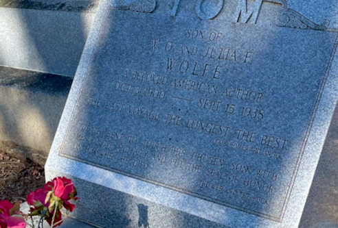
grave of Thomas Wolfe

“The Last Voyage. The Longest. The Best.”

And here is the grave of Thomas Wolfe. I really loved that line on his tombstone, above. Although “best?” I would venture to guess that everyone’s mileage would vary, so to speak…

angel on cemetery gate

Angel on the Cemetery Gate

Because of his 1929 novel, Look Homeward Angel, angels are kind of a recurring theme here.

Because my route through here was meandering and also because I was trying to avoid intruding on an actual funeral, I’m not posting a track. But if you click on the map or link above it will download as a pdf file. And if you go to the Riverside Cemetery page on the Romantic Asheville website, you can also download a walking tour, and of course, find out more about it. And finally, the address (to get you to the gate) is 53 Birch St., Asheville.

Pinetree & Explorer Loops

Posted By on January 14, 2021

Pinetree & Explorer Loops

5.6 miles; 434 ft. total ascent; Asheville, NC

Another trip around these two pretty trails. I saw nary a soul for the first 3 or so miles, then it was trail runners and mountain bikers up the wazoo. Just goes to show, you really have to keep alert. These are still, imo, some of the loveliest trails in the Bent Creek Experimental Forest.

Bent Creek from the bridge just west of Lake Powhatan

Although, if these trails are this busy now, in the middle of January, I can’t imagine what they’re like in full summer when the campground is in full swing. Guess I’ll find out…

You can find out more about the trails in the Bent Creek Experimental Forest from this excellent Hike Western North Carolina website. As always, click the image above for details about this hike and to download the gps track.

Another River Walk

Posted By on January 10, 2021

Another River Walk

4.5 miles; 298 ft. total ascent; Asheville, NC

It was a cold, very bright sunny day here in Asheville. Thought I’d take a quick walk before the NFL playoff games started, so I walked down Riverview Ave., through the Dog Park, and back along the “informal” river trail on the west bank of the river. Turns out mud is pretty slippery… fortunately I only got 1 knee very muddy, but still. Gotta remember that!

Poor Snowman

To start off I chose to reverse my usual order and walk down Riverview Ave. first. It was pretty steep going in this direction, but not as steep as going in the opposite direction. Anyway, it’s a nice neighborhood of closely-packed little houses with some fabulous views to the east and the west of the mountains surrounding Asheville, not to mention the view of the French Broad River. This little sad snowman was in somebody’s yard, quickly melting away.

The Trail

I love this little semi-legal trail (it’s technically posted “no trespassing” at its southern end, but nobody pays attention to that). It’s hundreds (literally) of feet below Riverview Ave., right along the banks of the river, and it has a nice feel to it.

There’s really not much (any) information about this trail online, and what I’ve posted is somewhat incomplete since it starts and ends at my house. But still, I have posted a gpx file, so click the link above to download if you’re interested.

Another Bent Creek Loop

Posted By on January 4, 2021

Another Bent Creek Loop

7.8 miles; 640 feet total ascent; Asheville, NC

I may be finally getting jaded about the trails in the Bent Creek Experimental Forest. This one was fine, but nothing special. Large portion of forest road, and some trails I’ve been on before… meh. Or maybe it’s just me. (Hike 1/52 of the 52-hike challenge).

Bent Creek

Bent Creek itself is the major waterway through this forest, and it’s very pretty.

Water Crossing

And it’s USUALLY bridged. This isn’t actually Bent Creek itself, but a tributary. And looks aside it wasn’t really very deep, but still. It was a long way to walk picking your way carefully from damp stepping stone to damp stepping stone. Eeesh. Didn’t get wet but man, I hate this. I’m such a klutz it’s only a matter of time till I slip off one stone and get wet to my knees…

You can find out more about the trails in the Bent Creek Experimental Forest from this excellent Hike Western North Carolina website. As always, click the image above for details about this hike and to download the gps track.